Data-Driven Decision Making
GIS-Enabled Spatial Analysis
With GIS spatial data analysis and location intelligence tools, enterprises can visualize geographic information to create infographics for better analysis and decision-making. Effective data capture, consolidation and use are imperative; TPIsoftware has exceptional data technology and tools to enhance business decision-making and forecasting, providing optimized and competitive strategic platform information for financial precision services, environmental planning, equipment and resource allocation.

Diversified GIS Spatial Data Services
 Geospatial Visualization
Graphics Engine
A virtual-real integration platform combining 2D and 3D graphs to create a visual graphic interface for various geospatial analyses
 Automatic Control
Smart Automation Control
Smart automatic control connections and mesurements to reduce deployment time of GIS solution
 Alert Notification
Secure Delivery & Early Warning
Alerts and proactive notifications via email and instant messaging services for early warning; can be connected to security guard and police
 Integration & Scalability
Highly Scalable Design
Fields and modules are all available for flexible configuration and scaling with data consolidation
Application Framework
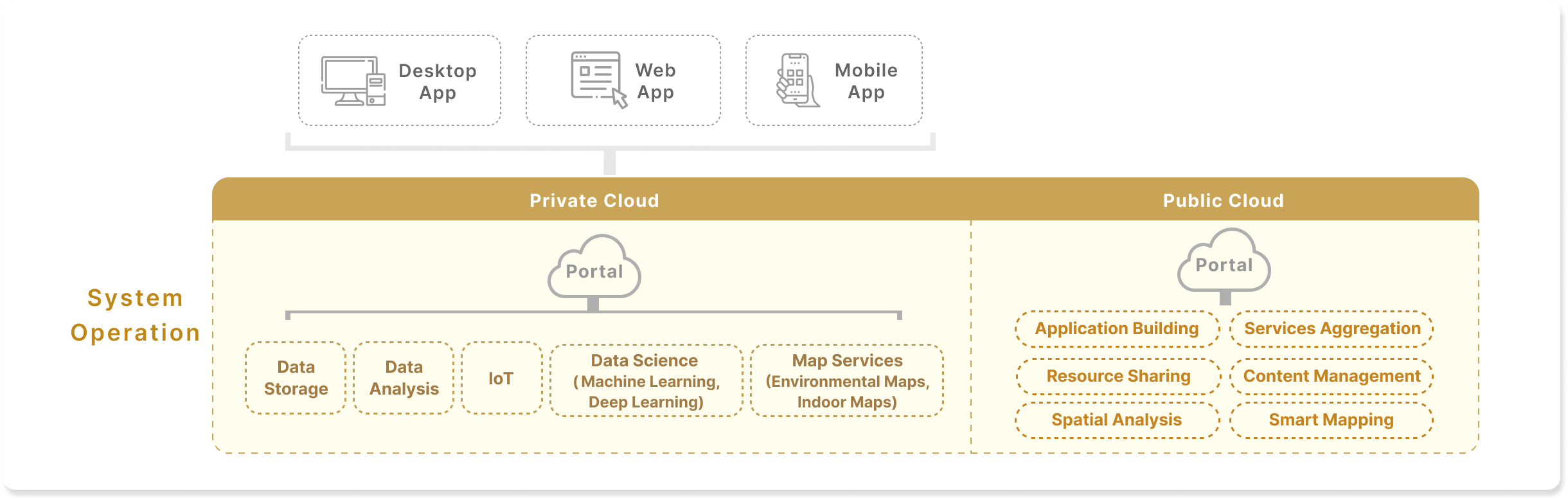
We Provide the Best GIS Geospatial Technology


Data Team
A professional team to analyze, interpret and integrate data across various systems for you

Integrated Interface
Precise visual display of spatial data analysis results with GIS engine to facilitate business decision-making and forecasting

Sustainable Service
Additional data application value-added services to quickly respond to market changes


Financial Risk Forecasting


High-End Medical Examination


Smart Building Management


Real-Time Vehicle Tracking
Success Stories
Smart Monitoring of Vehicles

Collecting driver behavior data through GIS technology and electronic fence system to provide monitoring and trajectory data insights. Alerts will be sent when events such as overspeed, idling, and rapid acceleration occur, and customized reports integrated with business intelligence are also available.
Insurance Subject GIS System

Providing insurers with geographical information of insurance subject before underwriting, with login mechanism for access control; converting latitude and longitude to the Mercator projection with formula and customized layer of ArcGIS to provide geographical information, which can also be horizontally integrated with Google Dual Maps and Street View.
Asset Management System

Building management and smart monitoring adopting GIS technology and IoT to comply with the financial industry requirements. Space or object equipment management can be flexibly divided and integrated to enable a more reliable and secure asset management and achieve the goal of smart building.